Newest
Topics:
For the latest news, see the NEWEST TOPICS page.
Google is too dumb to let me put the list of news in this column and falsely claims that all my pages are self-duplicates.
Google-NONSENSE
Google's so-called "Artificial Intelligence" is an abuse of the concept of intelligence!
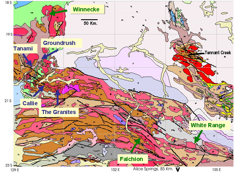
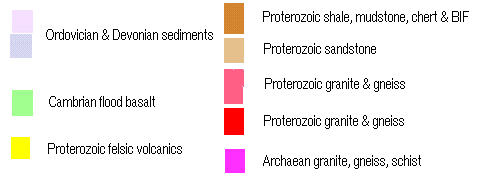
TANAMI GOLD - WHAT HAS BEEN ACHIEVED AND WHERE TO FROM NOW? NT Geological Survey - In house work, 2002.
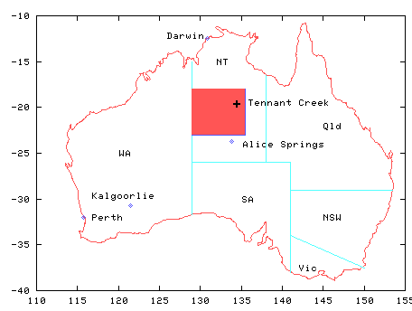
Reported at NTGS AGES 2002 conference, Alice Springs NT N.T. Geological Survey record 2002-0003
Project Staff:
Andrew
S Wygralak and Terrence P Mernagh
The Palaeoproterozoic
Tanami
Region is one of the most rapidly developing gold provinces in
Australia.
Its steadily growing gold resource currently stands at 12.5 Moz,
including
past production of 4.1 Moz. The entire Region contains some 60 gold
occurrences.
Most of these are concentrated in three goldfields - Tanami, The
Granites
and Dead Bullock Soak (DBS). Mined deposits usually contain reserves of
0.01-0.1 Moz Au. Unique in size and a notable exception is the Callie
deposit
(DBS goldfield). Prior to 30 June 2001, this open cut and underground
mine
produced 1.7 Moz Au and there is a remaining underground resource of
4.3
Moz Au. Other significant deposits include Groundrush (0.5 Moz Au),
Titania
(0.3 Moz Au) and Minotaur (0.1 Moz Au). The Coyote deposit in Western
Australia
also appears to contain significant mineralisation, but its resource
has
not been announced as yet.
In
1999, the Northern Territory Geological Survey commenced a major
multidisciplinary
project in the Tanami Province. This was designed to facilitate mineral
exploration in the region by provision of a new generation of
geological
maps and the development of mineralisation models. Results of this work
to date have been published in Hendrickx
et al 2000, Dean 2001,
Vandenberg et al 2001, Wygralak and Mernagh 2001 and Wygralak et
al 2001.
Earlier
reported metallogenic work (Wygralak and Mernagh 2001) concentrated on
the delineation of physico-chemical characteristics, and the origin and
evolution of hydrothermal fluids in the Tanami, The Granites and DBS
goldfields.
Pilot work has also been performed on the newly discovered Groundrush
deposit.
Mineralising
fluids in each of the goldfields have a unique physico-chemical
signature.
Fluids in the Tanami goldfield have a temperature range of
120-220oC
and contain almost no gases. Mineralisation occurred at shallow depths
of 0.4-1.8 km. Gold was precipitated as a result of decreasing pressure
and temperature. In The Granites goldfield, fluid temperature
was
in the range 260-312oC and the fluid contained significant
amounts
of CO2 mixed with minor CH4 and N2.
Gold
precipitated due to reaction of the fluid with host rocks containing
magnetite,
graphite and, in the case of the Bullakitchie deposit, carbonates. The
depth of mineralisation is estimated at 3.8-7.5 km. In the Callie
deposit
(DBS
goldfield), mineralising fluid had a temperature of 310-330oC
and contained CO2 and N2, but no CH4.
Gold precipitation occurred at a depth of 3.2-5.8 km as a result of the
reaction of fluid with carbonaceous sediments. In the
Groundrush deposit,
fluid temperature was in the range 390-430oC. Fluid was
dominated
by CH4 and there was a minor amount of CO2.
Mineralisation
occurred at depths of 5.7-8.3 km and phase separation was the
precipitation
mechanism.
During
the 2001 field season, similar studies were conducted on gold
occurrences
in the Winnecke area, Falchionprospect and White Range
deposit.
In the Winnecke area, spotty gold mineralisation in quartz
veins
hosted by the Winnecke Granophyre was previously reported by Otter
Gold.
Fluid inclusion and Raman spectrometry work on samples from this
locality
revealed that gold-related fluids had a temperature range of 200-220oC
and contained only minor amounts of CO2 and CH4.
Fluid inclusion data indicate that gold was precipitated from a boiling
fluid at shallow depths of 0.4-0.5 km.
Auriferous
fluids in the Falchion prospect had a temperature range of
320-340oC.
Raman analysis indicated the presence of CO2, CH4
and N2. These gases occur in extremely variable proportions.
This indicates either the presence of several fluids or one fluid,
which
has interacted with a variety of rocks so as to generate locally high CH4
during reaction with graphitic rocks and N2 during reaction
with sedimentary rocks. Another group of inclusions contains graphite,
suggesting the presence of an additional strongly reduced fluid. At
this
stage, there are insufficient data to estimate the depth of
mineralisation.
Fluid
inclusion and Raman work performed on Heavitree Quartzite-hosted gold
mineralisation
in the White Range deposit revealed boiling fluids, with
temperatures
in the range 320-340oC. Gold precipitated at a depth of 2 km
as a result of fluid boiling.
An
important
finding from our work is that granites played no genetic role in gold
mineralisation,
despite a close spatial relationship between mineralisation and felsic
intrusions. This statement is based upon different Pb/Pb isotopic
signatures
of granites and auriferous sulfides, and on the age difference between
the intrusives and mineralisation. The former appear to be about 100
million
years younger. Close spatial relationships between felsic intrusives
and
some gold deposits most likely indicate that the intrusives provided a
favourable structural setting for mineralising fluids.
A
1710 ± 20 Ma 40Ar/39Ar age has been obtained
for biotite associated with ore-stage veins in Callie and similar
younger
ages have been obtained from the Titania and Galifrey prospects
(Wygralak
et
al 2001). These are suggestive of a link with the Strangways Event
(1720-1730 Ma), which was responsible for widespread deformation and
metamorphism
in the Arunta province to the southeast of the Tanami Region. This
significantly
enhances the gold prospectivity of Strangways terranes in the Arunta
province.
Except
for the Tanami goldfield, where fluids have a strong meteoric water
signature,
oxygen and hydrogen isotopes of fluids do not distinguish between
magmatic
and metamorphic origin. The provenance of gold is therefore unclear,
but
it is likely that gold was scavenged from country rocks by
high-pressure
fluids circulating along D5 faults and percolating into
surrounding
rocks. Subsequent fault failures and a resulting sudden drop in
pressure
reversed the direction of gold-bearing fluids back into fault systems.
A
pilot study has been conducted into the suitability of acoustic
decrepitometry
as a cheap and rapid exploration tool to detect CO2 in fluid
inclusions hosted by hydrothermal quartz veins. In most cases, CO2
is a favourable gas component of fluids associated with gold
mineralisation
and its detection in quartz veins enhances their gold prospectivity.
The
decrepitometry was conducted on samples with fluid characteristics that
were already known from previous microthermometric and Raman work.
Based
on the samples studied, decrepitometry has proved to be a credible
method
for detection of CO2 in inclusion fluids that contain CO2-H2O±NaCl.
However, the method has limitations and is unable
to detect CO2 if it is mixed with significant amounts of
other
gases such as CH4. (This
statement is incorrect - see explanation below)
Note:
Decrepitation DOES detect mixtures of CO2 and CH4. Thermodynamics (the gas law) asserts that gases behave identically as temperature increases. But CO2 and CH4 can react to produce a carbon film and reduce the total internal gas pressure of the inclusion. The second author is unable to actually provide me with gas measurement data,
and claims this is because it exists only as rough work-sheets and the
calculations have not yet been done. In addition, samples
sent
to the laboratory were misnumbered and the first author declines to resolve
the
mis-numbering, which renders 3 of the samples as unreliable and/or
incorrect.
His assertion that decrepitometry does not produce a recognizable
low temperature decrepitation peak on CH4 rich fluids
cannot
be deduced from this seriously flawed data and in fact is inconsistent with the gas law!
The
first author's presentation showed a decrepitation graph on a sample number
that
was never submitted to the laboratory. The report's first author has declined
to resolve the sample
numbering
error and so 3 (at least) of the sample numbers cannot be accepted
as reliable data. (K. Burlinson comment)
Our
future
work will concentrate on: (i) tracing regional changes in the
physico-chemical
character of fluids; (ii) establishing the difference between fluids in
mineralised and distant areas; and (iii) establishing the chronology of
fluid flow. The first stage of this work will be focussed on THE
GRANITES,
HIGHLAND ROCKS, MOUNT SOLITAIRE and MOUNT THEO and will attempt to
establish
the differences in fluid characteristics between the Tanami and North
Arunta
provinces.
 Applied Mineral Exploration