There is plenty of information on the web about bicycle tour
destinations. But much less about the greatest cycling segments,
omitting the mundane stretches of cycling between these most
memorable or most scenic segments. And only rarely are maps of
these great cycling segments provided.
So here is my selection of the absolute best cycling segments
from my travels. I am a "lightweight" tourer and i do not carry
a tent etc., relying on local accommodation during my travels so
my touring is limited to routes where significant towns are up
to 200 Km apart. These routes are each one or more day cycling
segments of 120 Km. or more. They are all paved road routes.
I include a small overview map, and also a link to a "kmz" file
of the route which you can view in google earth and zoom
in for detail. Since 2013 I have used a GPS tracker to save my
routes.
Although these routes are in no particular order, I must admit
that the most spectacular routes in my opinion are:
- The Icefields parkway in the Rocky Mountains of western
Canada
- The Taroko gorge in Taiwan
- The bridges route across the inland sea of Japan from
Onomichi to Matsuyama. (Shimanami
Kaido)
Warning: The best rides and scenic routes almost
always involve mountains. Most of these routes require muscles
and endurance!
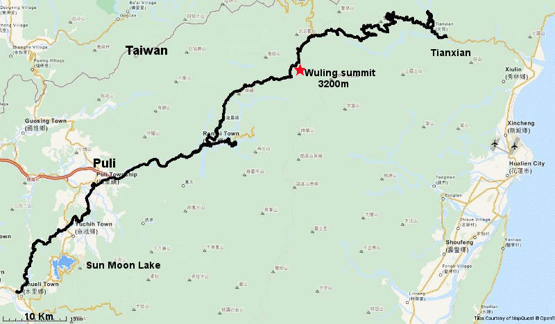
Taiwan
Across the island through Taroko gorge and over Wuling
summit. A truly spectacular but very strenuous ride.
Looking down on the cloud tops concealing lower Taroko gorge
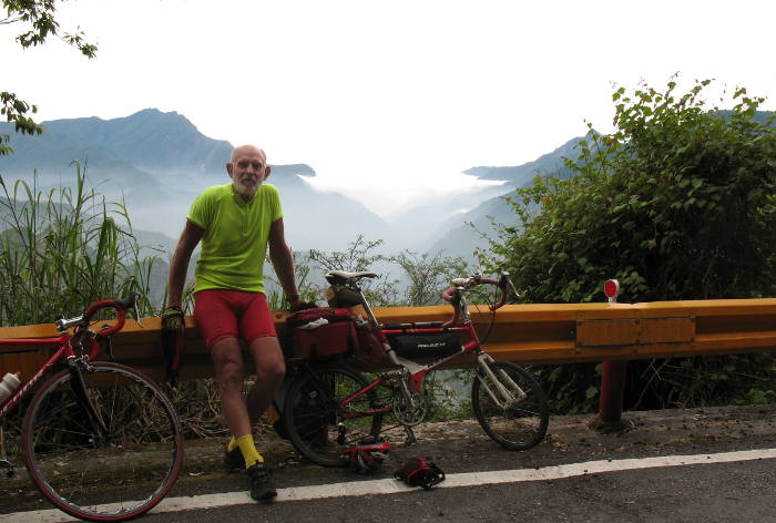
- Stunning scenery
- Very serious climb of about 3000m in 60 Km. Do not
underestimate this!
- More scenic climbing westwards, but also slightly more
demanding for the last 5 Km.
- Very little traffic on the east side - no buses or trucks
allowed.
- Ridden in 2011 (twice and both
directions!) ( Time: 2 days)
- Visit Sun-moon lake also - well established tourist resort
area.
Google earth route map of Taroko
gorge , Wuling summit and Sun-Moon lake.
Japan
Across the inland sea bridges from Onomichi to Shikoku
island.
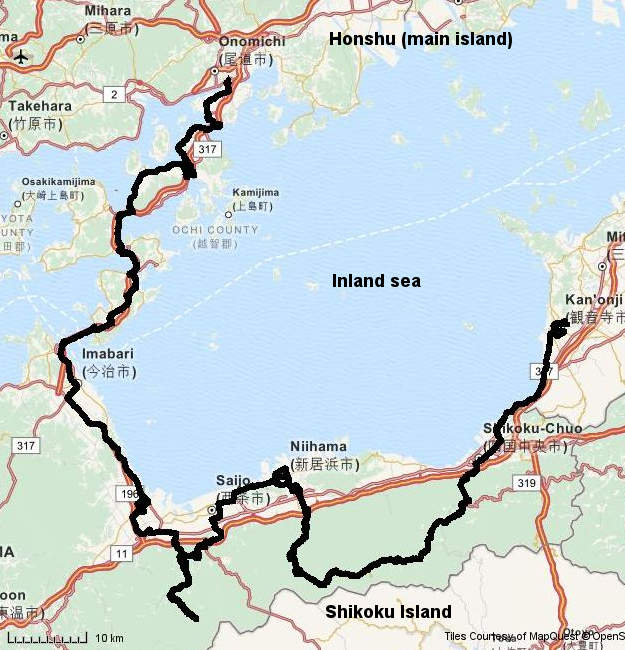
The only triple-span suspension bridge in the world. And it has
a bike pathway!
- A bicycle path route separated from traffic across some 7
amazing bridges for about 70 Km.
- Surely the world's most impressive (and expensive) bicycle
pathway!
- Great scenery and engineering
- Ridden in 2014
(Time: 3 days)
- Continue on in southern Sikoku island - great mountain
cycling and little traffic.
- You can avoid the mountains if you must.
You can ride to the north of the island and get a ferry back
to Honshu and nearby Osaka airport, but the traffic is heavy
and the scenery uninteresting as you near Tokushima (ferry
location).
Google earth route map from Onomichi to
Shikoku island
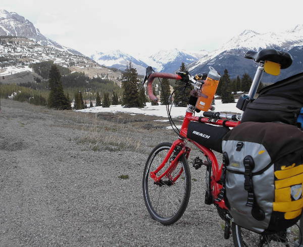
Canada
The Icefields parkway from Banff to Jasper through the
National Park
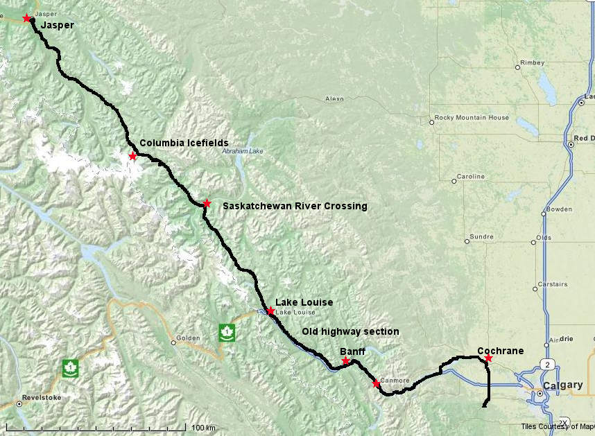
- Great scenic route through national park
- Plenty of climbing but mostly low gradient
- Cyclists do need to purchase a park entry permit
(tollgates near Banff, and north of Lake Louise)
- From Banff to Lake Louise the old highway (across the
river from the new freeway) is a superb low-traffic bike
route
- Canmore is a better (less touristic) stopover than
(expensive) Banff
- Stop halfway at Saskatchewan river crossing - hotel and
camping.
- Calgary traffic can be tough.
- Watch the weather - it changes quickly and there is little
en-route shelter
- Ridden in 2002 (Time: 3 days)
Google earth route map from
Canmore to Jasper
France
Aurillac to St. Etienne, in the massif central region and
across Puy Mary.
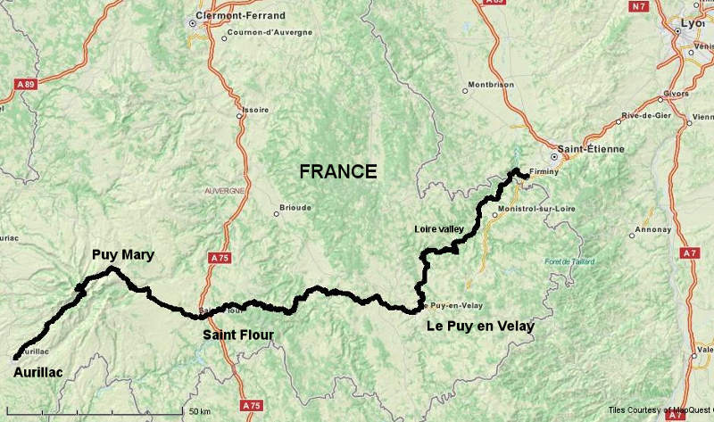
- Nice long climb up over Puy Mary
- Le Puy-en-Velay is an interesting town
- Great cycling along the Loire valley
- Ridden in 2007 (Time: 2 days)
Low traffic roads, 2-3 days cycling, not many services
between Saint Flour and Le Puy-en-Velay.
Google earth route
map Aurillac to St. Etienne, Puy Mary and Loire valley.
Route des Cretes, Vosges mountains NE France. (Pilgrim's
route)
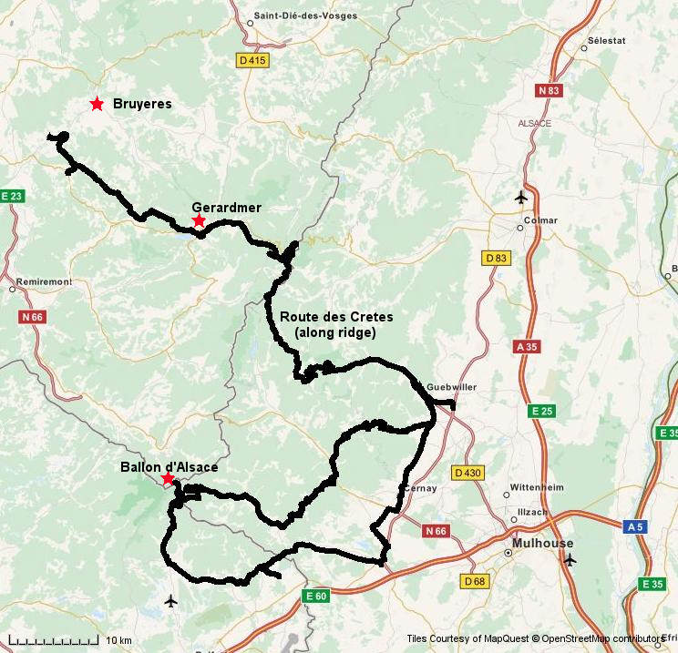
Lake Gerardmer
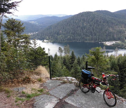
- Great route across the Vosges mountains with a long and
very scenic ridge-top ride along the pilgrim's route.
- Considerable climbing is necessary.
- Additional rides to famous mountain tops nearby are nice,
but only for masochists!
- Easy to avoid the main traffic routes on good secondary
roads with very little traffic
- Ridden in 2015 (Time: 2
days)
- Guebwiller is a cute small town suitable as a base for
more local rides.
- Gerardmer is a major tourist hub, best avoided!
Google earth route map from Deycimont
(near Bruyeres) to Guebwiller (Deycimont has a nice
B&B to stay at)
Spain
Picos de Europa national park and Lagos de Covadonga,
Austurias, Northern Spain.
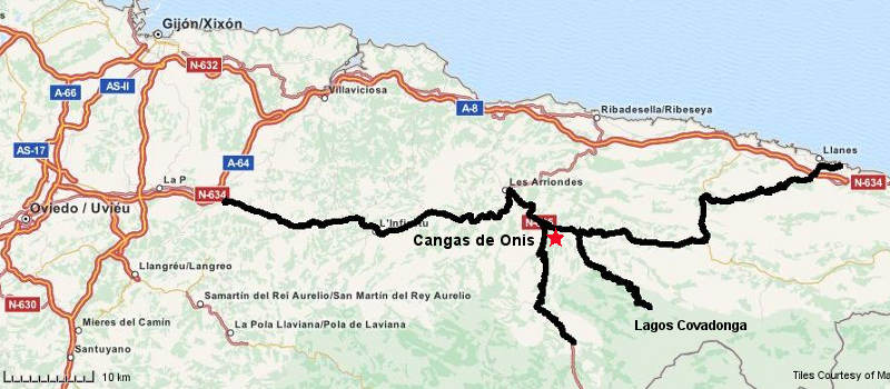
- Serious climbs south of Cangas de Onis
- Plenty of accommodation in Cangas de Onis to use as a base
- Nice valley ride to the east
- Ridden in 2007 (Time: 4 days)
Avoid the main roads - very heavy traffic on them
Google earth route map of the Picos
de Europa region.
China
North-western china between Chongqing and Xian in the
Qinling mountains. But the military dislikes lone westerners
in these touristic mountains!
These are 2 segments of my travels and I rode north from
Dazhou and later south from Baoji. I was detained by the
militia and police in Xixiang and involuntarily
relocated to Xian by bus.
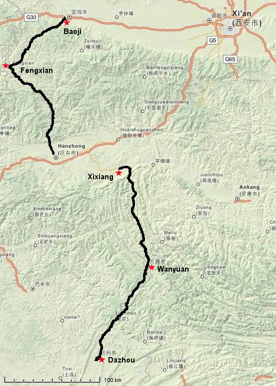
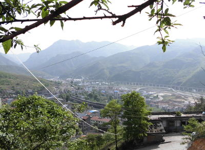
Mountain valley near Wanyuan
- Long and impressive valley route from Dazhou to Wanyuan
- Great scenic mountains and climbs on good roads from
Wanyuan to Xixiang with little traffic
- Long climb with great scenery from Baoji to Fengxian, good
roads, light traffic
- Pleasant scenic route with heavy truck traffic (but
considerate of cyclists) nearing Hanzhong
- Ridden in 2014 (Time: 2
days each segment)
- Xian is the location of the famous Terracotta warriors
tourist attraction
Google earth route map for both segments
in the Xian area
USA
Northern Arizona canyon-lands, into Colorado and mountains
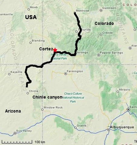
The high Coalbank pass between Durango and Silverton
- Chinle canyon and north are surprisingly impressive
"badlands" within Indian lands.
- Long distance from Chinle to Cortez with only a few
native stores for service points.
- Not much climbing except nearing Cortez
- Durango is pleasant and cycling friendly
- Cortez to Durango and particularly onwards to Ouray have
serious mountain passes.
- Ridden in 2015 (Time: 3
days)
Google earth rote map from Chinle Az.
to Montrose Co.
Australia
The Victorian coastline, the "Great Ocean Road route" from
Port Campbell to Apollo Bay and Queenscliff
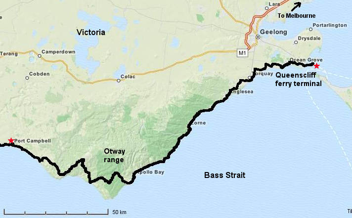
The Great Ocean road near Apollo Bay
- Scenic coastline road but traffic can be heavy,
particularly on weekends or holidays
- Significant climbs through the Otway ranges
- Wind can be an issue and can be either from the SE or W -
there is no protection!
- The ferry across the entrance to Port Phillip Bay is
bicycle friendly and goes to Melbourne's SE outer suburbs.
- Ridden in 2012 (Time: 2+ days)
Google earth route map from Port
Campbell to Queenscliff ferry terminal
South east Queensland - Kingaroy to the orange orchards at
Gayndah
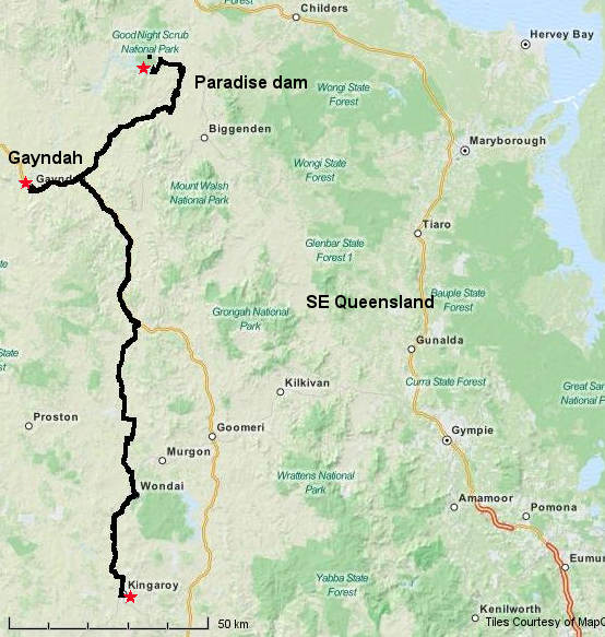
- No mountains or scenery - just a serene, long,
open-country, low traffic route, typical Australian back
country
- Almost no services north of Wondai.
- Gayndah is an irrigation region growing citrus fruit
- Paradise dam is a recreation and camping area
- A nice alternative route to the busy main arterial Bruce
highway further east
- Ridden in 2012 (and several
other times) (Time: 1.5 days)
Google earth route map from Kingaroy to
Gayndah and Paradise dam
Tasmania
A good cycling destination, but be prepared for rain,
particularly on the west coast.
- Logging trucks can be a problem in some areas, mainly
along the north coast.
- A complete circuit of Tasmania can be ridden in less than
10 days.
- Ridden in 2004. No route information
available.
NSW
Avoid NSW - it has an anti-cyclist administration and
police force which facilitates if not actually encourages
aggressive motorist behaviour against cyclists.
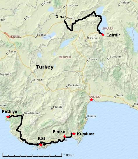
Turkey
Southern coastline west of Antalya and also Lake
Egirdir
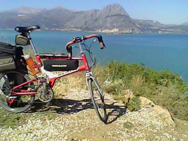
Looking westwards across lake Egirdir to the town of Egirdir
- Fethiye to Kas and Finike has great coastline scenery
- But there are some climbs
- Beware: the road is narrow and some drivers are very bad
- Finike is a tiny coastal town but there is one hotel
- Finike to Kumluca is uninspiring, but Kumluca is much
larger (and also uninspiring)
- Ridden in 2013 (Time: 2 days)
- ----------------
- Dinar to Egirdir is through nice irrigated orchard farms
nearing the lake
- Riding along the lakeside road is truly sublime
- Egirdir lakeshore is insect infested
- Egirdir is a low-key resort and old fortification
- Ridden in 2013 (Time: 1 day)
Avoid riding in Istanbul - it is cycling hell! Use the ferry
to Yalova (from Yenikapi terminal)
Google earth route map of both sections
Austria
Almost the entire country is great for cycling.
I could not pick just a single best segment so this selection
is 700+ Km from west to east. There are many scenic mountain
climbs, but also many pleasant river valley sections.

- Arlberg Pass is the hardest climb. You cannot cycle the
long freeway tunnel to avoid this climb.
- Traffic is mostly courteous, roads are good
- There are many bike paths but they can be hard to
navigate. I mostly used the roads.
- Not always easy to avoid road tunnels in the west
- Ridden in 2010 (Time: 5 days)
Google earth route map across
Austria
Slovakia
A deliberately hilly scenic route east from Zvolen
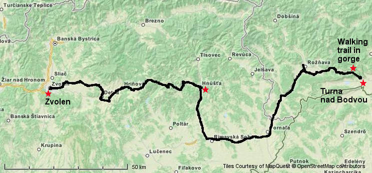
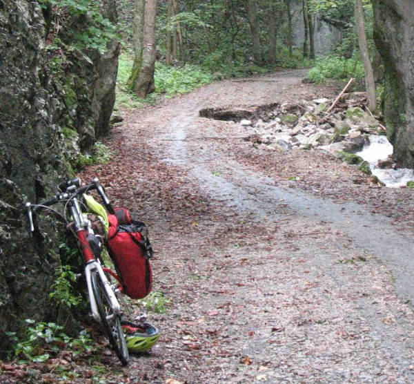
The walking trail in the gorge near Turna nad Bodvou
- Route avoids most main highways
- Many hills and valleys to cross from Zvolen to Hnusta
(including up to a ski resort)
- Hnusta is a relict of communist eastern europe
- Nice gorge foot trail near Turna. Too rough to cycle
- Ridden in 2010 (Time: 2 days)
Google earth route map Zvolen to Turna
nad Bodvou
Switzerland
A deliberately mountainous and scenic route from Thun to
Zurich with 2 high passes each day!
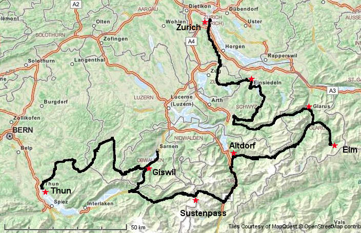
- Backroads crossing high mountain passes every day
- Sustenpass is a great ride
- Pragelpass west of Glarus is nice with very low traffic
- Cyclists are well respected by motorists in Switzerland
- Ridden in 2007 (Time: 5 days)
Google earth route map from Thun to
Zurich
New Zealand
North Island: The Coromandel peninsula
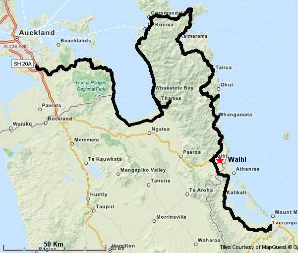
- Eastern exit from suburban south Auckland avoids the main
highway and traffic and is scenic with modest hills
- nice coastline scenery
- Hilly nearing Coromandel at northern tip of the peninsula
and beyond
- Low traffic as far as Waihi
- Nasty traffic on a narrow highway from Waihi to Tauranga,
but unavoidable en-route to Rotarua.
- Ridden in 2013
(3 days)
Google earth route map from Auckland
to Tauranga
South Island: Kingston to Queenstown and then over
Crown Range pass to Wanaka.

- Very scenic lake-shore route, no real climbs
- Long climb over Crown range pass (Avoid this by going via
Cromwell)
- Wanaka is a nice lakeside resort town
- Ridden in 2009 (2 days)
Google earth route map Kingston to
Queenstown and over Crown range pass to Wanaka
There are surely many more great cycling routes which I have
not yet discovered!
I hope these route experiences inspire you you find
your own cycling ecstasy.
 Applied Mineral Exploration