Newest
Topics:
For the latest news, see the NEWEST TOPICS page.
Google is too dumb to let me put the list of news in this column and falsely claims that all my pages are self-duplicates.
Google-NONSENSE
Google's so-called "Artificial Intelligence" is an abuse of the concept of intelligence!
A bicycle tour in North Queensland
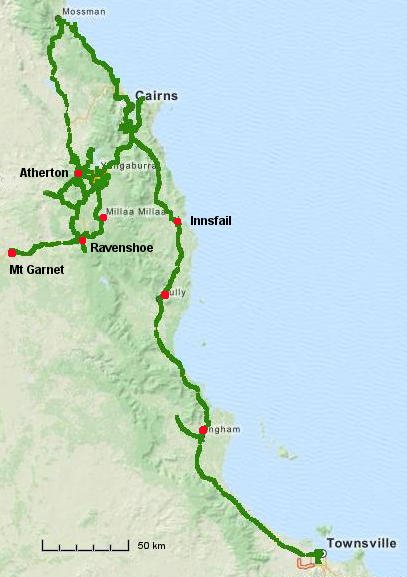
The Atherton Tablelands, 1700 Km, April 2016
The Atherton tablelands region, inland from Cairns, is an
interesting area geologically, because of recent volcanism and
also because it is a lush tropical farmland area well known for
its dairy industry. The original dense tropical forests have been
cleared in many areas to make lush open grasslands for cattle
grazing, but many areas of forest remain. Many volcanic craters
occur and conical hills which are remnants of volcanic necks are
common.
Starting from Townsville, it is some 350 Km north to Cairns and
the only coastal route is on the arterial Bruce highway, on which
there can be much traffic. But for most of this distance there is
a reasonable shoulder on the highway which facilitates cycling. In
April the prevailing winds were south-easterly so traveling north
is good. The route to Cairns is not hilly, but the climb to the
tablelands is significant and the southern tablelands can be quite
hilly. In fact the highest altitude declared road in all of
Queensland is here, near Ravenshoe, which is also the highest town
in Queensland. There are only 4 routes up to the tablelands from
the coastal highway.
From Innisfail to Millaa Millaa on the Palmerston road. This
is scenic, but hard as there is a major descent part way and
you have to climb back up again.
From Gordonvale (just south of Cairns) on the Gillies
highway. This route has many corners and motorists do not like
it and hence avoid it, so it is good for cyclists, but narrow.
This is my preferred route for an exciting, fast descent back
to Cairns.
From Cairns through Kuranda to Mareeba. This route is the
busiest with much tourist traffic also. I have never used this
route due to traffic concerns, but it can be cycled.
From Mossman southwards to Mount Molloy. A very pleasant
route with low traffic, at least outside sugar cane cutting
season, when trucks may be common.
To reach Mossman (and Port Douglas) from Cairns, the Bruce
highway is narrow with no shoulder and traffic is heavy, so
cycling is stressful, but the coastal road is very scenic.
Roads in the Atherton - Malanda - Millaa Millaa - Ravenshoe region
are narrow without a shoulder and there can be much truck traffic
on the main routes. But there are some pleasant alternative
secondary routes which are nice for cycling. The "Old Palmerston"
road from near Ravenshoe to Millaa Millaa was very pleasant and
scenic with light traffic as most traffic uses the new alternative
highway.
In early April daytime temperatures are still warm, from 30 to 34
C even on the tablelands. But nights are cool and pleasant (not
cold) in the Tablelands. The humidity can be high along the coast
at this time of year and there could even be a late season
cyclone, though that would be unusual.
This region is a very pleasant location for cycle touring.
 Applied Mineral Exploration