Newest
Topics:
For the latest news, see the NEWEST TOPICS page.
Google is too dumb to let me put the list of news in this column and falsely claims that all my pages are self-duplicates.
Google-NONSENSE
Google's so-called "Artificial Intelligence" is an abuse of the concept of intelligence!
Fosterville, Victoria.
Results of samples collected during the 1988
bicentennial gold excursion
A suite of 24 samples were collected form the fosterville
prospect in during an excursion organized by the bicentennial gold
88 conference. Sample locations are referred only to the excursion
guidebook map as GPS was not available.
The following description of the Fosterville geology is
from the excursion guide book, compiled and edited by D.G. Jones.
The Fosterville discussion is by G. W. McConachy, 1988.
Geology
The Fosterville Goldfield occurs in sedimentary rocks of
Ordovician age associated with the oxidized brecciated shear zones
and associated stockworks of the Fosterville Shear Zone. There are
few historic reports of visible gold and none of nuggets. Similar
styles of mineralization occur in apparently related structures
within the immediate district. These structures, steep major
faults with apparent normal displacement, may be auriferous
through supergene enrichment.
Structure and lithology
The Fosterville Goldfield is situated on the eastern limb of the
north-south trending structurally complex Strathfieldsaye
Synclinorium within a turbidite sequence of marine greywackes,
sandstones, mudstones, shales and slates of Ordovician age. Apart
from the resistant greywacke-sandstone sequence forming the
Sugarloaf Range, the Ordovician rocks are poorly exposed other
than in mine workings. Graded bedding is common with the sequence
and appears to be the most significant sedimentary structure.
The sequence is characterized by tight to isoclinal folding with
shallow plunge reversals and major strike faults, the most
significant of which is the Fosterville Fault, a planar
mineralized structure with significant mine workings over a strike
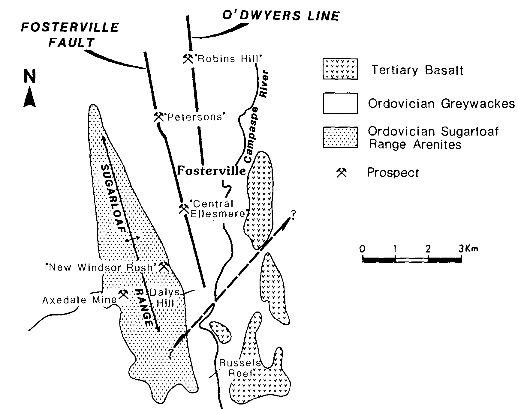
length of 8 km (Fig. 1).
Fig. 1 Fosterville location and
simplified geology
The fault zone trangresses both fold axes and regional bedding
at low angles, and is a complex feature consisting of shear zones
and fault breccias of variable width. Splay faulting and
associated shearing are common features. Minor drag folds occur in
finer grained rocks near the fold axis, which suggest that some
normal faulting (east block down) has taken place.
Irregularities in the normally linear workings may reflect the
presence of drag structures or of secondary faults crossing the
main fault zone. Periodic variation in the intensity of workings,
and slight changes in strike suggest an en-echelon mineralization
pattern in places.
Other mine workings within the tenements are probably controlled
by similar fault structures. In particular an adjacent strike
fault, sub-parallel to and approximately 1.5 km east of the
Fosterville Fault, hosts the O'Dwyers Line of mineralization with
intermittent mine workings over a strike length of 5 km.
Patchy outcrops of Tertiary basalt and gravel, and extensive
Quaternary alluvium, obscure outcrop over some of the tenement,
especially along the Campaspe River.
Mineralization
Gold mineralization along the Fosterville Fault Zone occurs in
oxidized brecciated shear zones and associated quartz stockworks
and silicified sandstones (Fig. 2) and has a strong geochemical
association with arsenic. The mineralized fault breccia and
associated stockworks are vertical to sub-vertical and are up to
30 m in width. Stockwork zones occur generally, although not
exclusively, on the eastern side of the main fault breccia (Fig.
3). The mineralized zones were frequently wide and planar, but
surface observations in conjunction with old mine data suggest
that in some areas shallow plunging ore shoots were controlled by
a combination of brecciation along the Fosterville Fault Zone,
lithology, the effects of cross faulting and the possible presence
of drag folds.
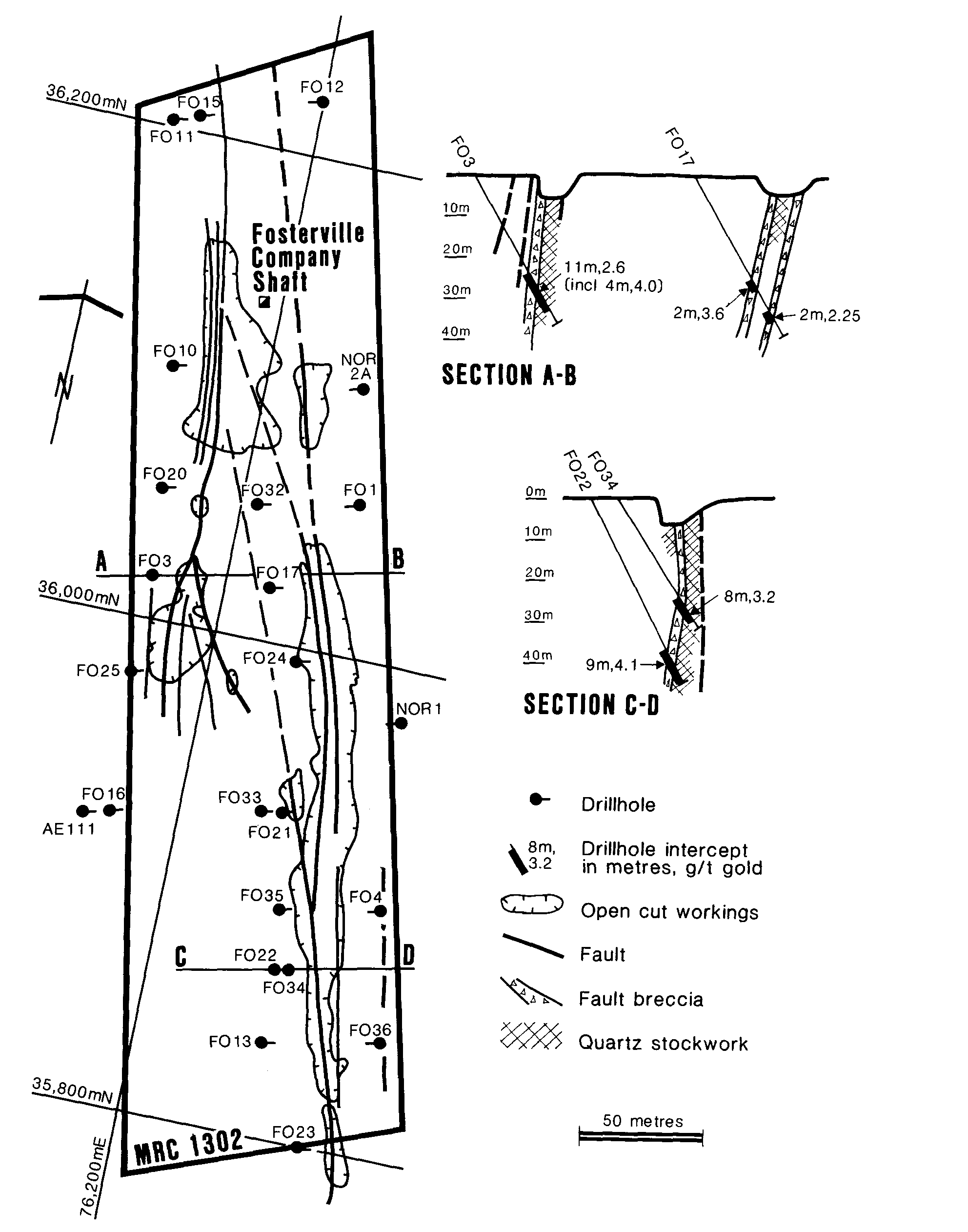
Fig. 2 Fosterville fault zone - Petersen's
prospect.
The original head grade of 3.5 to 4.5 g/t for most of the field
in conjunction with current drilling indicates an absence of
coarse gold.
Early mining extracted ore around 6 g/t by underground stoping
from shafts up to 45 m in depth with near-surface ore subsequently
extracted by open stope and glory hole methods. A significant
feature of this mining is the complete absence of mullock,
indicating that all material mined was of ore grade.
The most extensive workings and greatest gold yield along the
Fosterville Fault Zone extended from Rae's Area in the north to
Daley's Hill in the south, a distance of approximately 8 km with
almost continuous workings over an aggregate distance of 3.4 km,
the remainder of the field being obscured by soil cover.
Programmes of rock sampling by Lone Star, Apollo, Noranda and
BGL along the zone produced consistently anomalous gold values of
from 0.1 to 9.0 g/t (average 2.0 g/t) in more than 100 chip and
channel samples. A drill indicated resource in excess of 375,000
tonnes at 3.6 g/t has been outlined by BGL over an aggregate
strike length of 800 m of the Fosterville Fault Zone.
Similar styles of mineralization occur in apparently related
sub-parallel structures within the tenements, the more significant
being along the crest of Sugarloaf Range and the O'Dwyers Line
(Fig. 1).
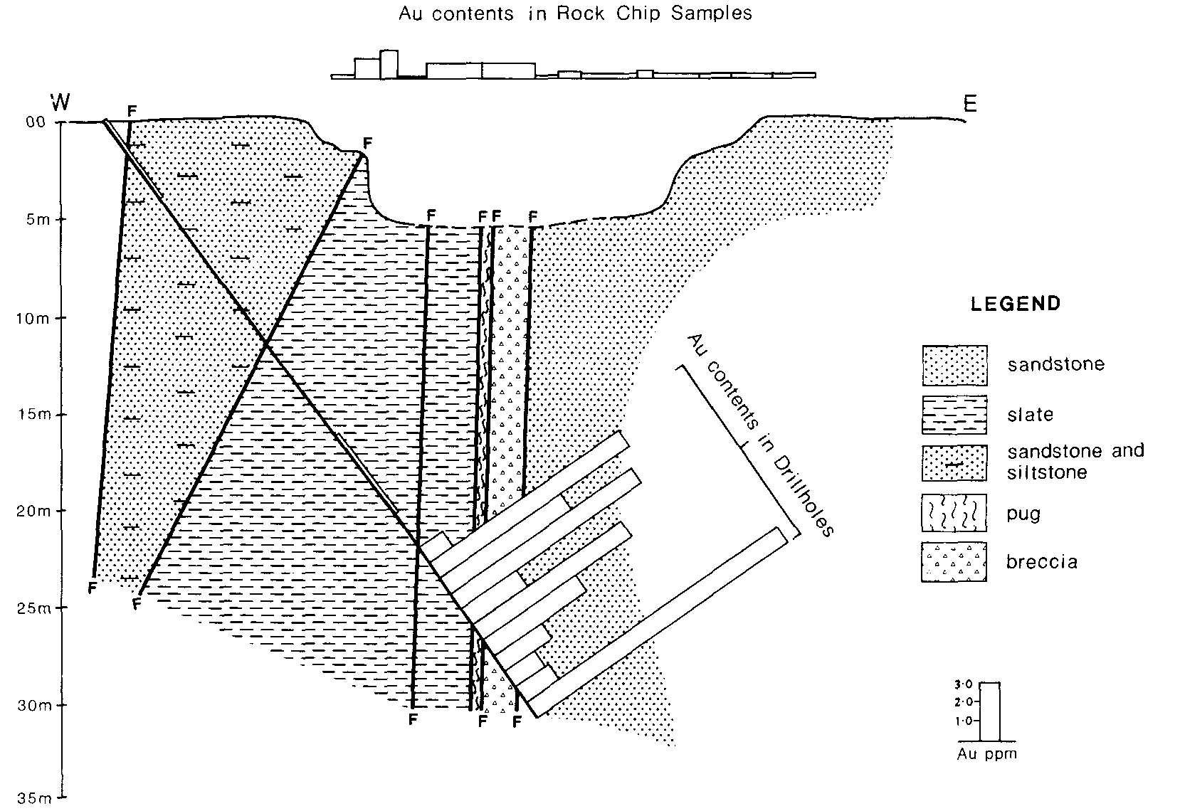
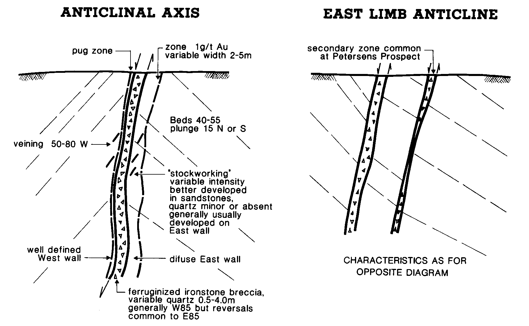
FIELD EXCURSION Stop FV.1 Petersen's Prospect
Petersen's area contains good examples of the various styles of
mineralization within the Fosterville Shear Zone. Shearing
intersects both anticlinal axis and east limb anticline positions
(Fig. 4).
The mineralized sediments and shear zone are characterized by:-
(i) Ferruginized ironstone breccia with variable quantity of
quartz and a sharp, well defined western wall, sometimes
associated with a narrow pug zone.
(ii) Quartz stockworking of variable intensity, most commonly
developed to the east of the major shear zone. Veining
predominantly dips 50 to 80° west.
(iii) Relatively broad distribution of gold in both drill hole
intercepts and rock chip sampling in the vicinity of the major
shear zone.
Fig 4 Simplified cross sections of typical Fosterville
mineralization.
Decrepitation Results
The main point of interest in these results is the
presence or absence of a low temperature decrepitation peak
between 200 and 300 C. When present, this indicates that the
inclusion fluids have high contents of CO2. Gold
mineralization tends to be found in association with such CO2
rich fluid inclusions.
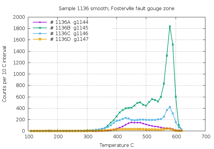
All 4 of the sub-samples of sample 1136 show no low temperature
decrepitation. This zone of the fault is interpreted to be of low
mineralization potential.
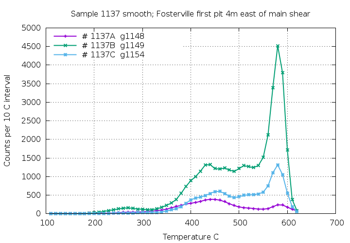
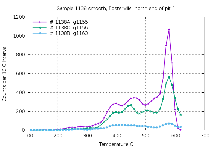
Pit 1
Sample 1137, sub-sample B shows modest low temperature decrepitation
caused by CO2 rich fluid inclusions. There are multiple
generations of quartz at this location with some lacking CO2
bearing fluids.
Sample 1138 sub-sample A has traces of CO2 rich fluids, but other
samples from this location lack CO2 bearing fluids.
The 6 samples from Pit 1 show variable, mostly low
contents of CO2 fluids. This area is interpreted to be possibly
mineralized but of secondary importance.
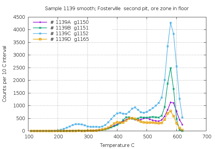
Pit 2
Sample 1139, sub-sample C shows decrepitation at 260 C due to CO2
rich fluid inclusions, but the 3 other nearby samples lack CO2
rich inclusions.
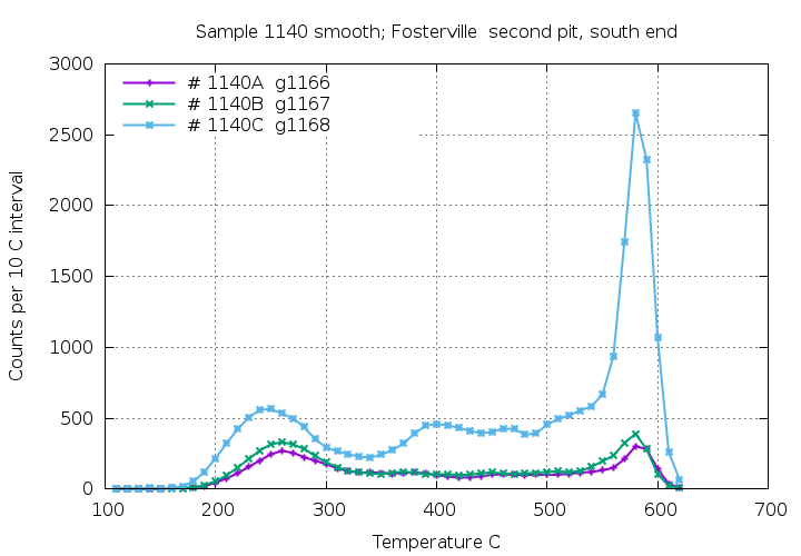
All 3 sub-samples of sample 1140 show significant low temperature
decrepitation and CO2 rich fluids are common in this
location. This is interpreted to be a highly prospective location
for gold mineralization.
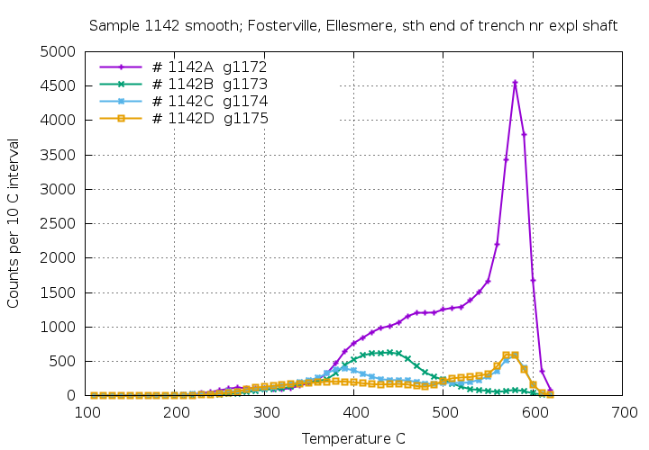
Pit 2 shows many CO2 rich quartz samples, particularly at the
southern end, and is a location of primary interest for gold
mineralization.
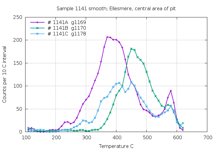
Ellesmere prospect
The 7 samples from this area show quite varied decrepitation
patterns indicating that multiple different quartz generations
overlap in this pit. Two of the samples show the presence of CO2
rich fluids, primarily in sample 1142A.
The Ellesmere area is of secondary interest for gold
mineralization.
In common with other areas of the Victorian gold province, CO2
rich fluids, as detected by low temperature decrepitation
anomalies, are typically closely associated with gold
mineralisation and these decrepitation features can be used as an
exploration guide. An overview of using fluid inclusion
decrepitation as an exploration
tool for gold deposits is here.
 Applied Mineral Exploration