Gold deposits from thick sedimentary
sequences, lacking volcanic units and with only a poor
relationship to granitic plutons are of considerable
interest because of the large quantity of gold mined in the
Central Victorian Goldfields in Australia in the late
1800s. The gold occurs in quartz veins hosted in
Ordovician slates and greywackes and is structurally controlled
by faulting and anticlinal hinges. Saddle reefs in Anticline
hinges were a major source of the gold in several areas.
The Meguma terrane of Nova Scotia shows
substantial similarities with the victorian goldfields, and has
numerous gold workings. By analogy with the victorian goldfields
it is inferred that this area has additional untapped potential
which has not been realized due to the greater difficulty of
exploration because of the thick vegetation and recent
glaciation.
Fluid inclusion information could help with
exploration for these deposits by facilitating the
discrimination between different generations of quartz and
perhaps directly identifying quartz which hosts gold. This
compilation of existing data from these areas shows that there
are significant variations in the decrepitation patterns in the
quartz. Different generations of quartz can be identified and in
many cases a quartz with a high level of CO2 rich
fluids in the fluid inclusions seems to be the main host for
gold mineralisation.
The presence of CO2 rich fluid inclusions, as shown by
decrepitation below 300 C, is the most noticeable feature of the
samples from across the Melbourne province and at The Ovens in Nova
Scotia. There is tendency for auriferous samples to show
CO2 rich fluids, but this relationship is confused by
the lack of complete geological and spatial relationships of most of
the samples. The lack of CO2 on the Dufferin deposit in
Nova Scotia is surprising, but only 2 samples from this deposit have
been analysed and additional sampling is required to determine
if this is a consistent difference.
In a few places it was possible to sample spatially overlapping,
different generations of quartz, such as the Deborah mine in
Bendigo and Ballerstedt's cut in Bendigo, and markedly different
decrepigrams confirm that one can clearly distinguish between
these quartz events. This also confirms that the quartz in many
cases was not a single event, but multiple events, not all of
which may have been auriferous.
There are variations in the temperature of the main peak from 400
C to 500 C across the samples. this probably reflects
changes in the formation temperatures of the quartz from about 320
to 420 C. On this limited data set it is not possible to
discern the causes or implications of this temperature variation,
but it may prove to be useful as an exploration guide given a more
thorough orientation study in an area of interest.
The samples from Dufferin, Nova Scotia, had unusually low levels
of decrepitation, and also significantly higher decrepitation
temperatures than most of the Victorian samples. The high
temperatures are similar to samples from Maldon, Victoria, and one
of the samples from The Ovens, NS. The Maldon mine is more closely
related to a nearby granite than most other Victorian deposits,
which suggests that the 2 Nova Scotia deposits sampled to date may
be closer than usual to granites, in contrast to a more distal
relationship with granites as seen at Bendigo and Ballarat.
The decrepitation method can easily recognize the high CO2
content fluids that are common in these types of deposit. It also
discriminates between multiple generations of quartz which are
often spatially overlapping and visually indistinguishable,
although important in the context of mineralizing events. Subtle
variations in dominant temperatures in the decrepigrams may also
be useful in recognizing auriferous quartz phases in an
exploration context. The method is applicable in the metamorphic
regimes of both of these provinces, and given a carefully planned
orientation suite of samples, could be a useful exploration
technique in these areas to identify potentially auriferous
quartz.
Victorian Goldfields
Decrepitation Summary
Representative data from 129 samples
collected in 1988
General Comments:
Samples are plotted in groups by sample number (collection
location).
The presence of decrepitation at low temperatures, between 200
and 300 C is indicative of high CO2 contents in the
inclusions. This is the simplest means of discriminating between
sample types and often helpful in discriminating between
auriferous and barren quartz.
Decrepitation analyses of the "G series" were not stored in
electronic format and these results have been manually
re-entered from paper copies. This group of 32 samples has been
selected from the total of 129 samples collected on the Gold '88
excursion to the central victorian goldfields, Ballarat
province.
Overview
An excursion to visit the Victorian goldfields was held after the
Gold '88 conference in Melbourne in 1988. These samples were
collected during that excursion. Access limitations prevented
collection of any samples from Ballarat.
This summary deals only with samples from the Ballarat province,
which includes the Bendigo area mines.
In this province, gold deposits are hosted within Ordovician
shale and greywacke sequences. The most productive gold regions
coincide with zones of high density of faulting.
From "Geology of Victoria", 2002, in press.
The Ballarat Zone is characterized by extensive,
tight, north-trending folds interrupted by several major
west-dipping regional-scale faults, which are not themselves
mineralized. The mineralized structures generally reflect the
regional structural style, in that they are mostly west-dipping
faults or are structures associated with the folds such as
bedding-concordant veins and saddle reefs, although east-dipping
faults are locally important (e.g. at Bendigo) . In these areas, mineralised structures are mostly confined to fold zones with a
sub-horizontal enveloping surface located several kilometres
west of major regional faults (Willman, 1995). In these areas,
the dominance of west-dipping mineralised faults suggests a
genetic link to the larger-displacement, yet unmineralised,
regional-scale west-dipping faults (e.g. Muckleford and Whitelaw
faults).
Important similarities have been recognised between the
Victorian gold province and the Meguma Terrane of Nova Scotia,
although the total gold production from Meguma is only 40 t Au
from 60 small deposits (Kontak & Smith, 1993; Kontak et
al., 1991, 1993). The Meguma Terrane consists of a Cambrian to
Devonian turbidite-slate sequence like Victoria, but without
equivalents of the Cambrian metabasalts. A major Devonian
thermal and deformation event that may be slightly diachronous
across the Meguma Terrane has also been inferred. The major
intrusion in the terrane, the South Mountain batholith, is
peraluminous (Allan & Clarke, 1981) and remarkably similar
to the Strathbogie Granite. Meguma gold mineralisation is
primarily associated with pyrrhotite and arsenopyrite with
some stibnite and limited pyrite. The proportion of deposits
with strongly folded quartz veins may be higher in the Meguma
Terrane compared to Victoria.
Recent work has highlighted the viability of studying
hydrothermal alteration as a guide to turbidite-hosted
mineralisation and as an indicator of the character of the
solutions associated with ore deposition. In particular, broad
zones surrounding mineralisation, characterised by
carbonate-white mica-sulphide alteration, provide an
exploration target significantly wider than the mineralisation. Elevated concentrations of CO2,
K2O, S, Au and As, together with low Na2O,
are also indicative of gold-related alteration. Further work
needs to be done to determine if potentially economic zones of
mineralisation can be predicted from their geochemistry, and
to better understand what controls the distribution of ore
shoots.
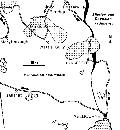
On the excursion, samples were collected at Lancefield, Fosterville,
Bendigo, Wattle gully and Maldon. The locations are shown on
the following map, together with the important Ballarat location,
which could not be sampled on this tour.
Location map of Gold '88 excursion sampling, Ballarat
Province, Victoria.
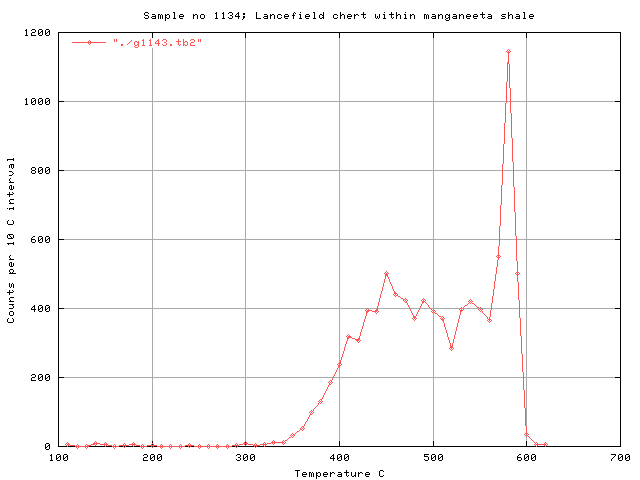
Lancefield
There are no gold workings at Lancefield and this area was sampled
as background for comparison. All but one of the siliceous samples
from Lancefield were of chert which showed no decrepitation
activity at all, as would be expected as there are no high
temperature fluid inclusions in such materials. Note that the
regional metamorphism has not introduced metamorphic fluid
inclusions into the chert. The decrepitation method is not subject
to interference from the effects of metamorphism, at least up to
greenschist facies metamorphism. One sample from Lancefield was of
vein quartz and has a typical decrepitation signature which lacks
low temperature CO2 rich fluid inclusions.
Unmineralised background - Lancefield
Run g1143, Sample 1134C, quartz vein in Monegeetta shale,
remote from gold mines
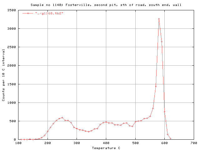
Fosterville
In 1988 Fosterville was an exploration prospect, but is now an
active mine. A suite of 24 samples was collected and these are discussed in full in a separate
page here.
Fosterville is one of the few Victorian deposits in which the gold
is disseminated in the host rock rather than concentrated in quartz
veins.
The Fosterville samples tend to show a CO2 peak, which
is especially prominent in sample 1140C, shown here.
The main part of the Bendigo goldfield has a strike
length of 17 km (7 km being productive), is up to 4 km wide, and
is remarkable for its regular trains of chevron folds that
control the distribution and geometry of mineralisation. Most
production was derived from the hinge zones and east limbs of
three anticlines, namely the Garden Gully, New Chum and Hustlers
anticlines, but significant gold was also mined from adjacent
anticlines. The whole goldfield is confined to a zone of
symmetrical and persistent folds with the eastern edge of the
goldfield being sharply delineated, and the western margin
coinciding with a more gradual decline in production and number
of mineralised structures (Willman & Wilkinson, 1992).
Mineralisation is mostly hosted in reverse faults. Many of the
smaller faults appear to be true limb thrusts that have short
dip lengths and were generated as fold-accommodation structures
after fold lock-up. However, some of the larger mineralised
structures may have more significance regionally and extend to a
greater depth. The famous saddle reefs are fault-controlled
composite structures which range from being a folded
bedding-concordant vein through to complex structures involving
the interaction of limb thrusts, fold hinges and
bedding-concordant veins (Willman & Wilkinson, 1992).
Detailed stratigraphic correlation across folds suggests that
the mineralised intervals on adjacent anticlines may represent
similar stratigraphic positions (Johansen, 1998). The
west-dipping reverse faults and associated extensional vein
zones are similar in character to those at Ballarat, Castlemaine
and Daylesford. For example, the Deborah Fault is interpreted to
have a strike length of more than 1 km and is associated with
minor east-dipping splay faults (Turnbull & McDermott,
1998). Domal culminations along the main anticlines tend to
correspond with well-mineralised portions of the folds. Overall,
folds in the Bendigo goldfield plunge about 10 degrees away from
the centre of the field.
Bendigo area and sample locations
Numbered Circles are sample sites used in this study:
1 - 1143
Presumed barren quartz in the very productive Paddy's gully
anticline.
2 - 1144 Diamond hill
, Napoleon anticline, presumed barren quartz.
3 - 1145 Victoria hill,
Ballerstedt's cut old workings in the very productive New Chum
anticline.
3 - 1146 Victoria hill,
Rae's pit old workings in the very productive New Chum anticline.
3 - 1147 Victoria hill,
mullock from old workings in the very productive New Chum
anticline.
4 - 1148 & 1149
Central Deborah mine, underground samples, productive
Deborah anticline.
The other very productive anticline in this district, Hustlers, is
off to the east of this map.
The Paddy's Gully anticline is also known as the Garden Gully
anticline.
The New Chum anticline is also known as the Nell Gwynn anticline.
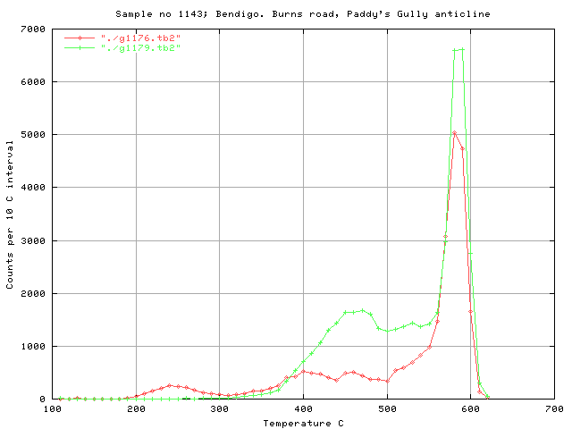
Bendigo area surface samples
In Bendigo, there are many anticlinal axes and saddle reefs on
many of them have been exploited. The samples from the Paddy's
Gully anticline are remote from any known workings and presumably
barren although this anticline was one of the 3 most productive in
the district. Sample #1143A below contains CO2 although
it is distant from the productive sections on this anticline. It
may be an indicator of the nearby auriferous potential of this
anticline.
Run g1176, Sample 1143A, Barren quartz vein
Run g1179, Sample 1143C, Barren quartz vein
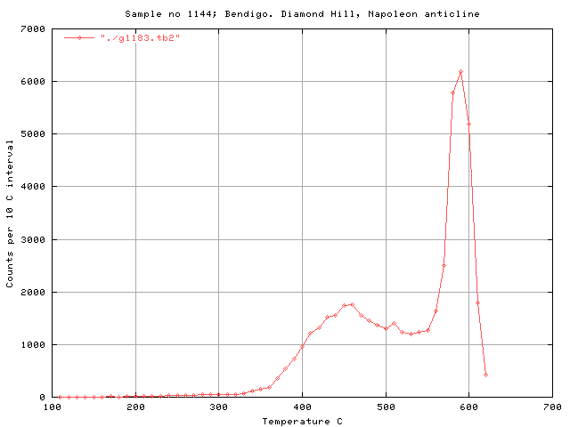
The napoleon anticline is rarely mentioned as mineralised and
this is considered to be a barren sample. Note that it lacks CO2.
Run g1183, Sample 1144A, quartz from road cutting
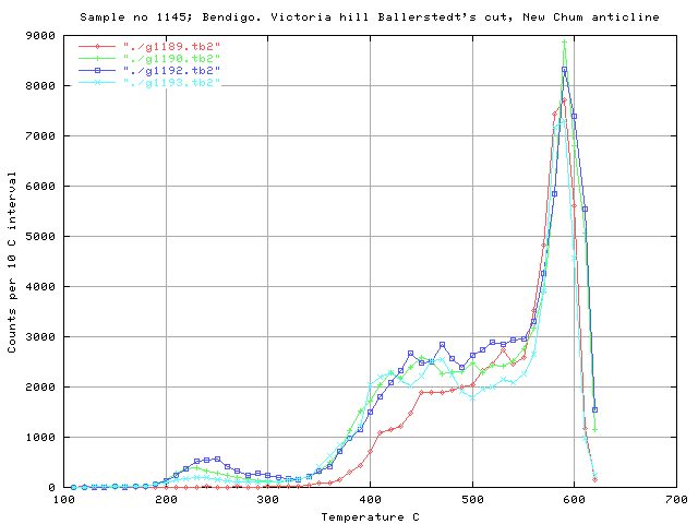
The Victoria hill samples are from old workings on the very
productive New Chum anticline. Note that the different orientation
quartz veins (1145A is perpendicular, the others are
parallel to the axial plane) show a different response and the
different generations of quartz in one location can be
distinguished.
Run g1189, Sample 1145A, Qtz. vein perpendicular to anticline
axis, ferrug, 10cm thick
Run g1190, Sample 1145B, Massive qtz. reef in anticline
Run g1192, Sample 1145D, Thin 5-10cm thick qtz veins parallel to
axial plane
Run g1193, Sample 1145E, Thin 5-10cm thick qtz veins parallel to
axial plane
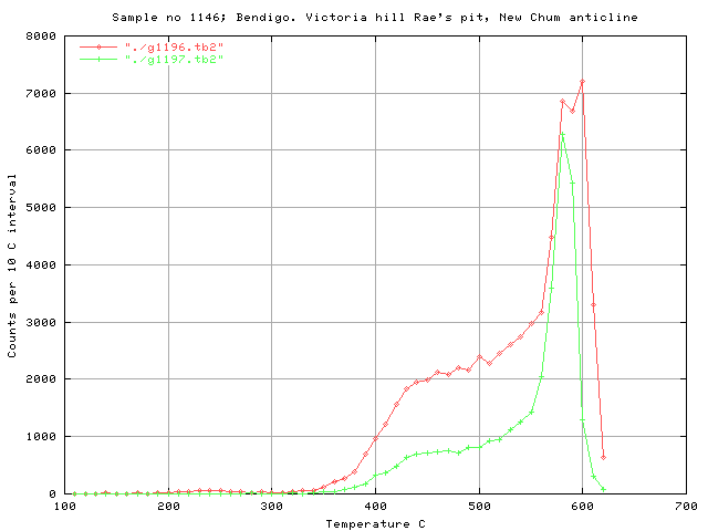
Here again, the axial plane perpendicular sample (g1197, #1146D)
is distinct from the axial plane parallel sample, having lower
counts at 400 to 500 C.
Run g1196, Sample 1146C, Vertical vein parallel to axial plane
Run g1197, Sample 1146D, Vein perpendicular to axial plane at same
location as 1146C
The euhedral mullock quartz is quite possibly a late stage barren
quartz. Its different decrepitation pattern and lack of CO2
probably represent barren quartz.
Run g1201, Sample 1147A, Quartz within unoxidised shale.
Run g1204, Sample 1147D, Euhedral quartz mullock from Rae's pit
Bendigo - Deborah Anticline and Mine
The Central Deborah mine was one of the most productive in the
Bendigo area. The auriferous quartz (#1148C & #1148D) show
a high CO2 content, while barren and doubtful samples
lack CO2.
Run g1205, Sample 1148A, Barren quartz lens
Run g1207, Sample 1148C, Massive Saddle reef qtz, sulphide and Au
rich
Run g1208, Sample 1148D, Massive quartz-chlorite, low grade zone
Run g1209, Sample 1148E, Quartz from the back, near the alamac
lift
Run g1210, Sample 1148F, Grey quartz, wall zone of saddle reef
sample 1148B
Run g1215, Sample 1148B, Saddle reef equivalent. Milky qtz, vein
centre. (vein edge is 1148F)
Although the samples 1148B and 1148C are closely related, they
have markedly different CO2 responses indicating the
presence of small scale inhomogeneity and zoning, even within
mineralised quartz of the reef. Closely related quartz from the
centre (1148B) and margin (1148F) of the same vein both lack CO2,
and are indistinguishable from each other here, but distinct
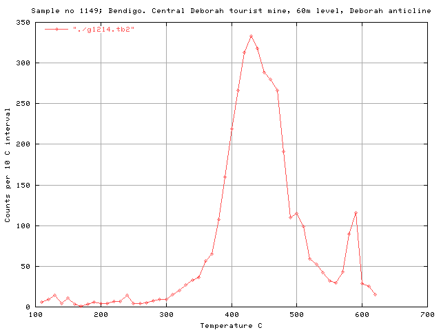
from the presumed barren sample 1149 (graph below), which has a
slightly lower temperature peak at 430 C.
Run g1214, Sample 1149, Thin quartz veinlet
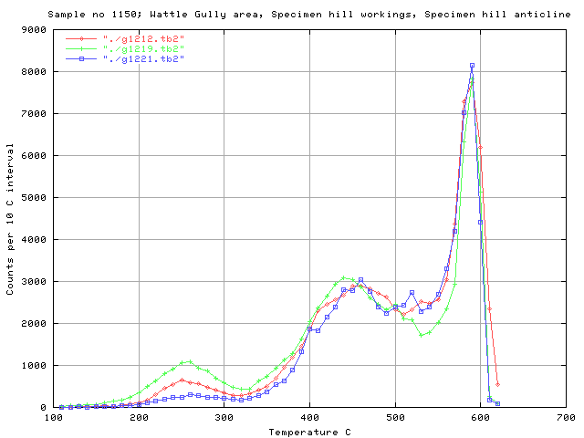
Wattle Gully
All of the samples collected at Wattle Gully in the old Specimen
hill open cut pit had substantial CO2 contents. The
quartz veins seem to be of a single stage only with consistent
decrepitation patterns on all samples.
Run g1212, Sample 1150A, Quartz in eastern limb, back to the saddle
Run g1219, Sample 1150E, Saddle reef quartz in anticline nose
Run g1221, Sample 1150G, Saddle reef quartz in anticline nose
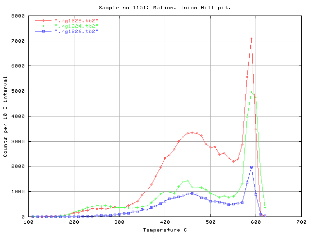
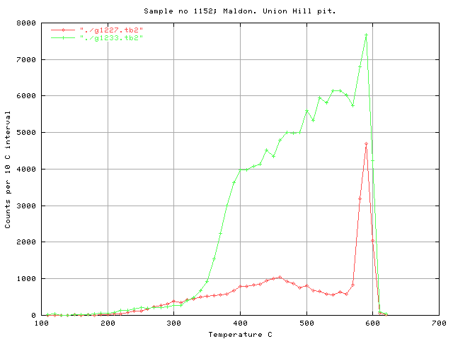
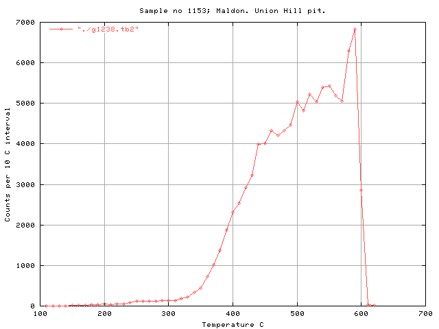
Maldon
There are several different decrepitation styles indicating a
complex quartz paragenesis at Maldon. Most samples contain low
level CO2 peaks but it is unclear how the decrepitation
patterns relate to mineralisation other than noting that the one pit
contains many different quartz styles.
Run g1222, Sample 1151A, Eaglehawk vein
Run g1224, Sample 1151C, Massive quartz reef
Run g1226, Sample 1151E, Thin 5cm vein in stockwork
Run g1227, Sample 1152A, quartz spur vein near Lindscott's reef
Run g1233, Sample 1152F,
Run g1238, Sample 1153C, Thin vein, west of ore zone, out of best
ore.
Conclusions:
Several different types of decrepitation pattern occur on these
samples collected from a range of deposits and background
areas in central Victoria. The most noticeable pattern is that due
to the presence of CO2 rich fluids in some, but not
all samples. There is also a tendency for these CO2 rich
samples to be related to known mineralised samples in most cases.
The variations in decrepitation can be used to distinguish different
types and parageneses of quartz and potentially to identify
auriferous quartz. Using fluid inclusions rather than gold analyses
to identify auriferous quartz would be advantageous as one may be
able to identify distal variants of the mineralised quartz
where the actual gold content is too low or too spotty to be
analysed reliably.
A complex small scale zonation of the quartz can be seen,
indicating that the quartz deposition was not a single event. It
is not resolved from this data if the gold mineralisation is
constrained to just one (or a few) of these quartz events, but it
is clearly not associated with all the quartz events.
Contrary to some biased opinions which have been expressed,
quartz samples in these types of deposit are not uniform and
invariant, but are of multiple parageneses and the fluid inclusion
decrepitation technique can be used to discriminate between these
different quartz materials. Understanding of these variations
would be of considerable practical utility in exploration or
exploitation of the gold deposits hosted by this quartz.
 Applied Mineral Exploration